During the first half of 2019, iDrone Services Ltd. was part of a pilot initiative aimed at improving the provision of agricultural insurance for maize farmers in Zambia and Malawi. We supplied drone imagery data that helped estimate crop growth, and an agricultural insurance company used this information to compensate farmers with lower-than-expected yields. Despite the difficulties we had, such as those related to the long distances between the fields that were surveyed, this was a successful experience – and one which can easily scale up.

Maize is Zambia’s most important crop in terms of cultivation, production, consumption and income generation. It is grown all over the country and on all kinds of soils – by small-scale farmers, by cooperatives and by commercial farms. Many new varieties have been launched during the past 50 years, and the country has seen a lot of changes in terms of seed production and availability. Yet for a long time the national yields have remained low and the country still finds it difficult to produce enough for its own population. Excellent varieties of maize are available, yielding up to 15 tons per hectare, but the adoption rate by small-scale farmers has been low. Most farmers continue growing the old, less productive varieties: many studies have shown that they are not aware of the new varieties, or do not have enough information. The government would like small-scale farmers to increase their yields and make their investments more profitable, but it has struggled to see this happen. And while Zambia has a good climate for maize (considering both rainfall and temperature), many farmers, researchers and politicians wonder if this is not changing already.

Insuring crops
The rapid development of new drought-resistant varieties provides good news for many farmers, but they still face many risks and the potentially severe impacts of climate change. As they increase their investments and improve their production capacity, farmers should be in a position to get compensation for low yields and crop losses caused by natural disasters, extreme weather conditions or drought. The use of drone imaging technology can support farmers in the face of climate change, as plant growth can be monitored during the entire season. This can offer insurance companies the necessary data for deciding when to compensate insured farmers.
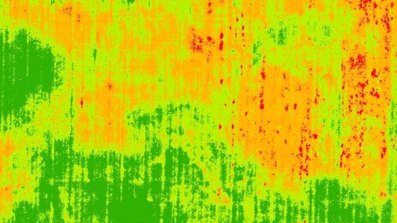
Processed multispectral, high-resolution imagery can be used to estimate the chlorophyll content of vegetation. As part of an early warning information system, this can provide real-time actionable information Chlorophyll concentration varies with vegetation growth, so an estimate of this concentration, in different parts of the field and at different moments, can give a clear indication of the state of the crop. Farmers can then intervene in specific parts of their fields and increase the total farm output. But measuring chlorophyll concentrations also helps them get insured against potential losses. Insurance companies require evidence of the actual state of the crop to compensate farmers. Drones equipped with multispectral sensors are the best devices to provide this, reducing the need for insurance agents to scout the fields themselves.
The survey process
Pula Advisors is a European insurance advisory company that offers livestock and crop insurance to farmers across Africa and Asia. It follows a slightly different approach: it targets people who have never bought insurance before, starting with smallholder farmers. The company develops and distributes insurance products together with tailored agronomic advice that protects these farmers from risk, and helps them secure a yearly income.
Pula contacted our company, iDrone Services Ltd, and invited us to discuss the outline of a project that would help them provide a more efficient and effective service. We discussed the main ideas for about two months and signed a contract in June 2019 (see box). They asked us to collect multi-spectral aerial imagery of small-scale farmers’ fields using drones, and in this way assess their maize yields. For this we used the Normalised Difference Vegetation Index (NDVI). The index maps generated by processing the multispectral imagery captured by the drones, provided enough evidence and helped assess the crops, enabling them to compensate insured small-scale farmers for low yields (with losses as a result of an irregular weather or from natural disasters).
| How did it work? While Pula regularly bundles agricultural inputs with insurance and agronomic advisory services, this project was innovative as it focused on the use of remote sensing technology. More specifically, it was built on four key aspects: Technological: using technology such as remote-sensing data, drones, etc. to refine the yield insurance products as well as increase the cost efficiency of the business model. Client acquisition: integration of insurance with agricultural inputs, i.e. a “pull product” that farmers actively demand and purchase through technology enabled and incentivised rural trusted agro-dealers, thus overcoming challenges of distribution and client acquisition. Adaptive learning: rather than pushing SMS agronomy, advisory based on farmer needs, focus on behaviour changes through adaptive learning and provides location and farmer specific climate and agronomic circumstances. Business process: yield index insurance, i.e. departure from weather index and indemnity-based insurance, enhanced through technology. For more information, follow this link. |
We conducted the aerial surveys, acquiring two-band “RED & NIR leaf reflectance images”: these were perfect for the assignment because of the sensor optics and weight of the payload – and therefore the cost needed to carry out these surveys. Our client processed the images on R-studio software to derive the crop yield, using the NDVI algorithm mentioned above. We acquired multi-spectral images for six farms in three districts of Zambia, and in two districts of Malawi.
Challenges
Unfortunately, the process for obtaining an official permit for flying drones has been challenging. The Zambia Civil Aviation Authority (ZCAA) published their drone regulations in June 2016, including guidelines on drone safety and limitations. But only three companies have registered with ZCAA in the last three years. Surveys are not easily approved, and the process for issuing permits usually takes time. It was only after many requests that we got a temporary operation permit. And together with the regulatory challenges, it also took us time to properly understand our clients’ requirements, and to prepare the assignment. This was partly because our client did not have the farmers’ GPS locations, which would have made the process of planning drone missions much easier.
We also had to pay attention to the timing of the drone flights. By the time we received our first payment and were ready to fly, in July 2019, most of the farmers had already harvested their crop. July is very late in Zambia and it is difficult to find small-scale farms where maize is still growing, and most of them are rainfed. We could therefore only survey irrigated fields, reducing the scope of the whole initiative. Moreover, our operation costs increased, as the farmers we went to were spread out in remote, non-adjacent areas. Like most small-scale maize farmers in Zambia, the fields we surveyed were of only two hectares or less, making each imagery acquisition process more time consuming.
Compensating farmers
The client used our data for compensating farmers with lower yields based on metric depending on the client and location where the maize farms were.
Seed producing companies which partner with Pula Advisers sell a bag of maize seed for a price which includes the insurance premium. There is a unique serial number found inside the bag, which the farmer sends by SMS to agents of Pula Advisers. This enables the company to determine the farmer’s location and the amount of seed bought. If insufficient rainfall or pests compromise the crop and the insured farmer records a failed harvest, the insurance company compensates him / her based on the terms of the policy, the metrics of which depend on the client and location where the maize farm is located. Affected crops could be assessed using the evidence acquired with the three-stage drone imagery we provided. The work we did would have to be expanded, collecting data when the crops emerge, during the vegetation period and just before the harvest. With these data the insurance analytic system will be easily able to differentiate the causes for high or low yield production, identifying the total number of farmers affected.
The crop protection scheme using drone surveys can work even better if farmers are in cohort or under a co-operative association. In this case farms are adjacent to one another or at least located in nearby areas, reducing the costs of the drone operation and data capture.
In this study we also realised that the same data sets can be used to demarcate individual farm boundaries, calculate the size of a plot, and determine the crop type and vegetation growth status, all of which opens up further potential markets. The survey data is also useful for the farmers themselves as it helps them determine the exact area on which their crops are planted and the number of plants, making it easier to calculate the amount of agro-chemicals they need.
About the Author:
Subi Thomas
Director
iDrone Services Ltd.
Email: idroneagroservices@gmail.com
https://idrone4ag.org