Maptech Consultants Ltd. is a Kenyan company that provides surveying and mapping services. Since 2017, we are using drones in our regular operations. One of our projects involved the mapping of an informal settlement called Kahawa Soweto, allowing local officials to use the high resolution images to aid them in the development of urban improvement plans. Experience, quality equipment and proper planning have shown to be necessary elements for a successful drone mapping exercise.
My passion for drones started in the year 2016 when I was in the Netherlands pursuing an M.Sc. program in geo-informatics. In one of the courses I learned how to prepare and execute a flight plan. I was so intrigued when the drone took off and automatically took high resolution images, that I immediately decided to buy one and take it back to my country. Fast forward to 2017: I came back to Kenya with many new ideas and a drone in my backpack. Little did I know that this knowledge and the drone would breathe new life into the company I started with a friend back in 2013.
My name is Fredrick Onyango and I am the CEO and co-founder of Maptech Consultants Ltd., a surveying and mapping company based in Nairobi, Kenya. We provide services to both the public and private sectors, and we have seen the efficiency of our activities increase after we started using modern technology. Since we included the use of drones in our operations, we have been adding value to the products and services we offer to our clients. Before we started using drones, we could not offer aerial mapping services to our clients because the technology was too expensive. But since drones came into the market, we found a cheaper alternative to the traditional way of doing aerial surveys. These products include orthomosaics (stitched images), 3D models from images (as shown below), and topographical maps. We collaborate with clients working in different fields, like civil engineering, urban planning, and surveyors.
In October 2018 we diversified our services to offer Unmanned Aircraft System-based advice to farmers. This involves using Unmanned Aerial Vehicles – drones – to collect farm data, which we analyse. The results of the analyses are used to give advice to the farmer on what to do to increase crop yields. An example is the development of fertiliser prescription maps that tells the farmer which crops require more fertiliser than others. This new service being offered resulted from a partnership agreement with the Technical Centre for Agricultural and Rural Cooperation ACP-EU (CTA). We co-financed the procurement of a state-of-the-art drone which has a multispectral sensor, suitable for crop health detection. In addition, we acquired licensed software, which we use to process drone images. The partnership is on-going and we now benefit from technical advice on how to run a drone business efficiently. It also offers us networking opportunities within the African continent.
Mapping Kahawa Soweto
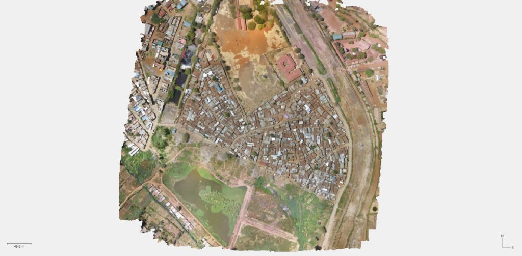
In March 2019, we were awarded a contract by the Ministry of Lands to provide aerial mapping services to map informal settlements in a slum known as Kahawa Soweto. The slum is located approximately 19 kilometres northeast of Nairobi. This was the perfect task for the drone we had. We then generated base maps from the processed aerial images. These base maps were to be used by enumerators during the exercise of conducting a socio-economic survey in the area. Figure 3 shows an example of a high-resolution drone image.
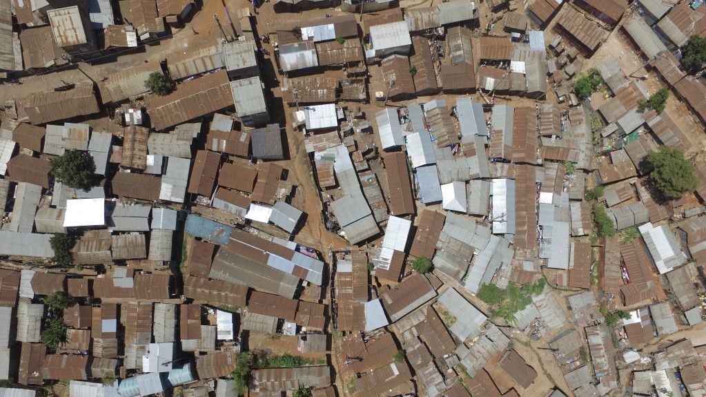
Kahawa Soweto is one of the areas included in the Kenya Informal Settlement Improvement Plan. The purpose of this project is to improve the living conditions in slums and to do this, planning is required. Planners require high-resolution images to aid them in the development of plans for the informal settlements. From high resolution images planners can clearly see the layout of different structures on the ground. For example, they can identify structures that would need to be demolished in case a road needs to be widened, and they can identify open spaces that need to be left as they are – and this is where Maptech came in.
The approach we took first involved a meeting with the client to discuss the scope and details of the project, in order to properly plan for the data capturing exercise. We had to determine the exact location of the site to ascertain if it was a restricted area – like close to an airport, next to the president’s residence or within a national park. The next step focused on the necessary authorisation from the relevant authorities to fly our drone, for which the client wrote a formal letter requesting a temporary permit to fly. Then we had to get acquainted with the community elders, introduce ourselves and explain our mission. Failure to do this would have led to doubts among the Kahawa Soweto inhabitants about what we were doing and this could have prevented us from operating the drone there. Afterwards, we were ready to fly.
It was crucial to plan the flights before taking off, because the plan helped to determine how many flights were required. This then informed us how many batteries were going to be needed. Flight planning involved setting a geographical boundary within which we wanted to fly. The flying height was also set – a crucial parameter that determined the resolution of the images. The higher you fly, the lower the resolution, and vice versa.
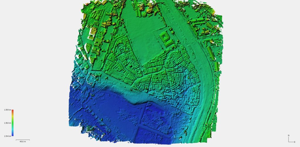
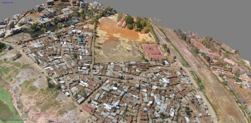
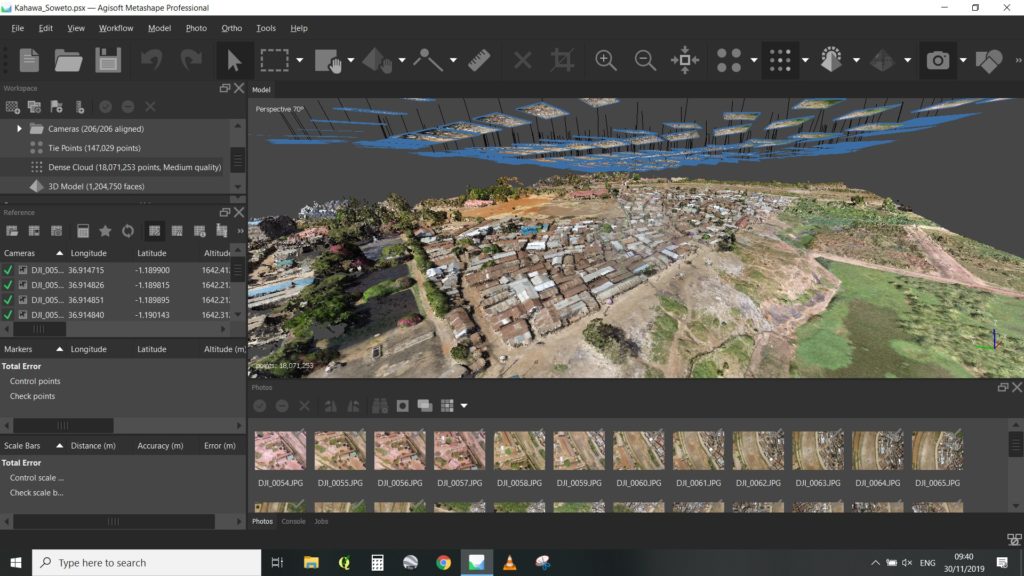
We flew over an area of approximately six hectares. The images came out perfectly and we were ready for the next step: image processing This was done using a licensed version of Agisoft Metashape professional. Figure 4 shows the user interface of Agisoft Metashape professional. We generated a 3D model, an orthomosaic (a map generated by stitching up the individual drone images) and a contour map showing elevation levels. Features were then digitized from the orthomosaic to generate a base map. The contours were overlaid onto the base map and the final product was ready to be delivered to the client.
On delivery, we could tell that the client was impressed with the results. It was the first time they ever used drone mapping services. The results were accurate and from the images a lot of details could be seen – from power lines to drains.
Lessons from drone mapping
We achieved very positive results, but we faced a few difficulties while we implemented this project. It took longer than expected because of the extended period it required to get a temporary permit to fly. A considerable amount of time was spent talking to the village elders, explaining the project and how the drone works. Finally, the drone had a slight malfunctioning and it was unable to take pictures. This forced us to fly over the same area a second time.
From the challenges faced, we learned a few things that would change our approach next time we conduct a similar project. First, we will let the client know about the lengthy process involved in acquiring a temporary permit to fly so that the planned timelines include this expected delay. Secondly, explaining to the community what we intend to do cannot be avoided. So, this will also be communicated to the client in advance, including it as part of the planning process. Finally, to mitigate the risks of malfunctioning equipment, we have now prepared spare equipment that can act as a backup.
Despite the challenges, we completed the project successfully and this was attributed to some key elements. This was not our first project, so we had an experienced team with specialised skills and knowledge on how to execute the project. We also had state-of-the-art equipment and software that helped us to generate the required end products. These included a drone with a high-resolution camera, a computer with high computing capabilities and powerful software to stitch the images together. The software was co-funded by Maptech Consultants Ltd and CTA, and acquiring it was a major milestone in our business.
Conclusion
The use of drones in Africa is largely hampered by a lack of regulatory frameworks, even if these are currently being developed in some countries. The technology is new and often not yet fully appreciated by potential clients. All in all, we have had both good and bad experiences with the use of drones. The good experiences outweigh the bad, and we see this as a technology that will make our business more sustainable. This is because we believe that there are more drone applications to be explored in the future: there is a need for high resolution image data. All we have to do is to master the technology, offer the best services we can to our clients and continue spreading the word by highlighting the benefits of using drones in various application areas.
About the author:
Fredrick Onyango
Director
Maptech Consultants Limited
Email: oredo3@gmail.com
Phone / WhatsApp: +254 727 480 934
http://maptech.co.ke