As urban areas continue to expand, with larger sizes and occupation densities, there is a need for local governments to ensure an orderly development process and manage the physical space and the environment. This entails the preparation and implementation of different types of development plans. While these are necessary to ensure the well-being of those living in towns and cities, they are not always respected. Drones can play a very important role in the preparation of these plans and can help the local authorities make sure that they are followed.
Land use plans are one of the ways with which the Physical Planning Departments of Ghana’s urban areas ensure that good practices are always followed, considering issues as diverse as aesthetics, convenience, economy, harmony, health and safety. Essentially, these are zoning plans which outline the future location and type (residential, office, retail, industry, recreational) of any development activity. When land use plans are comprehensively followed, they can help create workable and conducive towns or settlements. At the same time, they serve as an effective and efficient control mechanism is to prevent or address the problems that are mostly associated with urban growth, such as the formation of slums, congestions or poor accessibility.
The process of continually observing and checking the progress or quality of the development initiatives in a particular jurisdiction is known as land use monitoring, and is largely the responsibility of the Metropolitan, Municipal and District Assemblies (MMDAs). Currently, most of the Physical Planning Departments and of the Works Departments in the MMDAs in Ghana follow traditional monitoring methods, involving field inspections and manual measurements. However, this approach is expensive and time consuming, and does not guarantee a complete overview. In many cases, the field officers or building inspectors who are responsible for a specific area are unable to complete these inspections, with of many of them being discouraged by the time consuming tasks involved in the process. As a result, it is common to see that the plans are not followed, that many open and public areas are encroached and that many unauthorised developments go unnoticed.
A new approach
Any initiative to collect exhaustive, accurate, and meaningful spatial data about any given phenomenon needs to be efficient, paying special attention to the costs involved. Recent studies have shown that a monitoring exercise such as those required by the MMDAs can be more effective and less cumbersome with the use of digital technologies and Unmanned Aerial Vehicles (UAV), or drones. UAV technology offers unlimited capabilities and a range of benefits in several fields. In terms of development control, drones can be used together with other Geographic Information System (GIS) applications to map and analyse large areas in a very short time. The costs involved in monitoring a particular jurisdiction can be reduced significantly, while at the same time providing much more accurate results.
To demonstrate this, Ziongate Geospatial & Research Services Ltd (ZGRS) collaborated with the Physical Planning Department and with the Works Department of the Oforikrom Municipal Assembly and with the Traditional Council of Kodiekrom, both of them in the Ashanti Region, in the southern part pf the country. Our objective was to test an innovative procedure for monitoring development. The main focus of this initiative was to leverage UAV technology with GIS-based decision support applications, and use it to identify unauthorised developments, such as parcels found within nature reserves and parcels with uses other than those specified in the current land use plans.
Stakeholder Consultation and Engagement
The PPD and the Traditional Council of Kodiekrom got together to discuss all the relevant issues before work started, organising a stakeholder consultation meeting. This event helped all those involved share information, showing the different roles and responsibilities taken by the PPD and WD with regards to development control in the area. Also, through this meeting, baseline data such as the land use scheme of Kodiekrom was made available. The Traditional Council provided relevant data that was helpful in determining the boundaries of their land.

Data acquisition
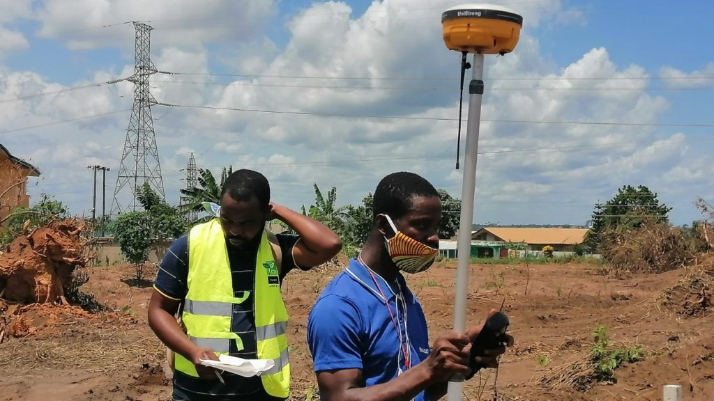
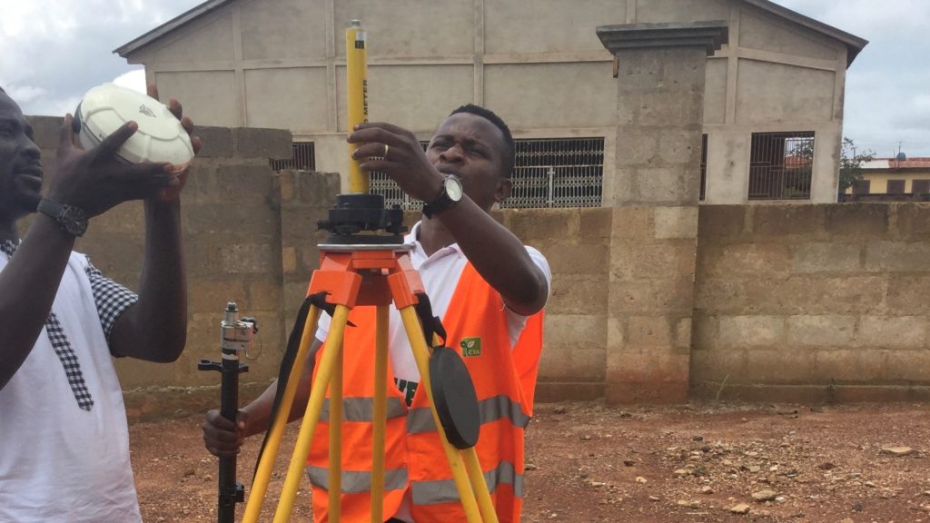
The next step was to acquire the relevant dataset for this project. This started by determining the exact boundaries of the Kodiekrom township, considering that boundary dispute is a quite common issue in the Ashanti Region. We focused therefore on the exact legal boundaries of Kodiekrom, paying attention to the changes seen in the past. Based on the information provided by the Traditional Council of Kodiekrom, the boundary outlined in the land use plan that was approved was no longer valid since certain portions of land had been ceded to Deduako, the neighbouring township. Hence, a new boundary was outlined on the ground. As part of this process, representatives of the PPD, the WD and of the Traditional Council joined a field survey where ZGRS staff picked ground coordinates of the new boundary using a Trimble Real Time Kinematic (RTK) GPS device.
Mapping with the unmanned aerial vehicle
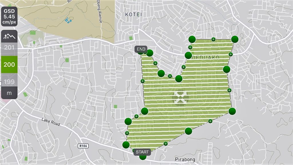
The assignment continued with an aerial mapping process, planning flights around the new boundary. This was done using the Pix4D drone flight application. Mapping large areas has never been easy using conventional surveying methods. Therefore, a Matric 210 real time kinematic (RTK) drone was deployed to map the entire Kodiekrom township. The UAV captured data at an elevation of 200 meters and at a resolution of 5.45 cm/pixel. In order to further improve the accuracy of the whole process, ground control points (GCPs) were collected for geo-referencing and check points processing.
Data processing and spatial analysis
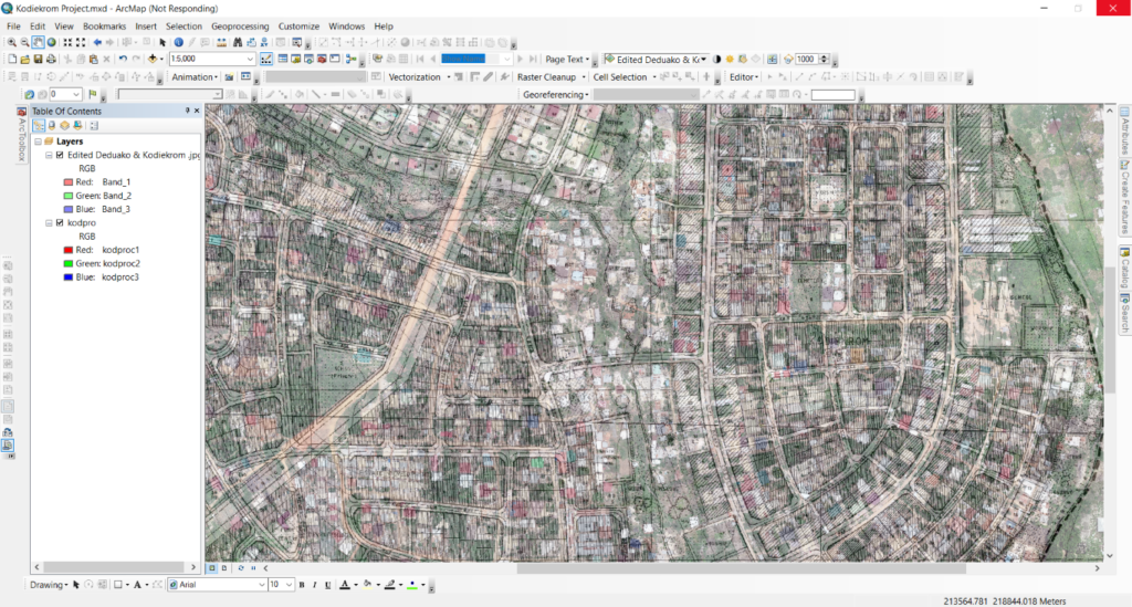
The process was completed with the analysis of the images and the data collected. At first, we used Agisoft Metashape Professional, a stand-alone software that performs photogrammetric processing of digital images and generates spatial data such as orthophoto and digital elevation models (DEM)to process the images captured by the sensor mounted on the UAV.

Thereafter we imported the data into our GIS (ArcMap) to perform an overlay analysis, whereby we superimposed multiple data sets (representing different themes) to establish the relationships between them. It was first necessary to geo-reference the planning scheme and the orthophoto within the same coordinated space. Unauthorised buildings or parcels were then identified using a selection-by-location approach. This was complemented with a field inspection, verifying whether the proposed land uses were respected or not.
A more efficient process
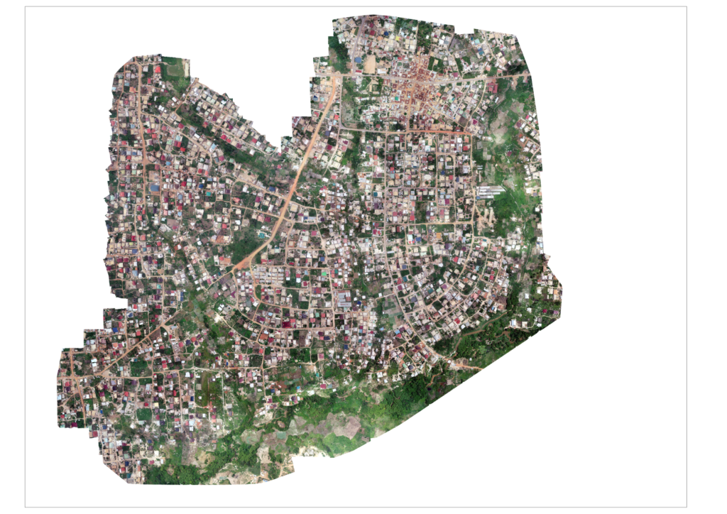
Mapping large areas is now a much easier process. With the introduction of UAV technologies, it is now possible to access unreachable areas and map large areas at a very high resolution. Our aerial survey was successful: in less than an hour, a team of only two persons (a pilot and a field observer) mapped a total area of 770 acres, or more than 300 hectares.
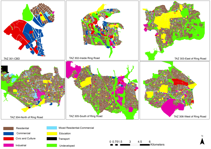
Image processing was done using the Agisoft photogrammetric software. After processing the images, an orthophoto and digital terrain and surface models were produced. The orthophoto was cloud free and had a resolution of 5.45 cm / pixel. At this resolution it was possible to clearly identify buildings and their main features. It was also possible to see a plot’s boundaries usually represented by walls or fences and entrance gates.
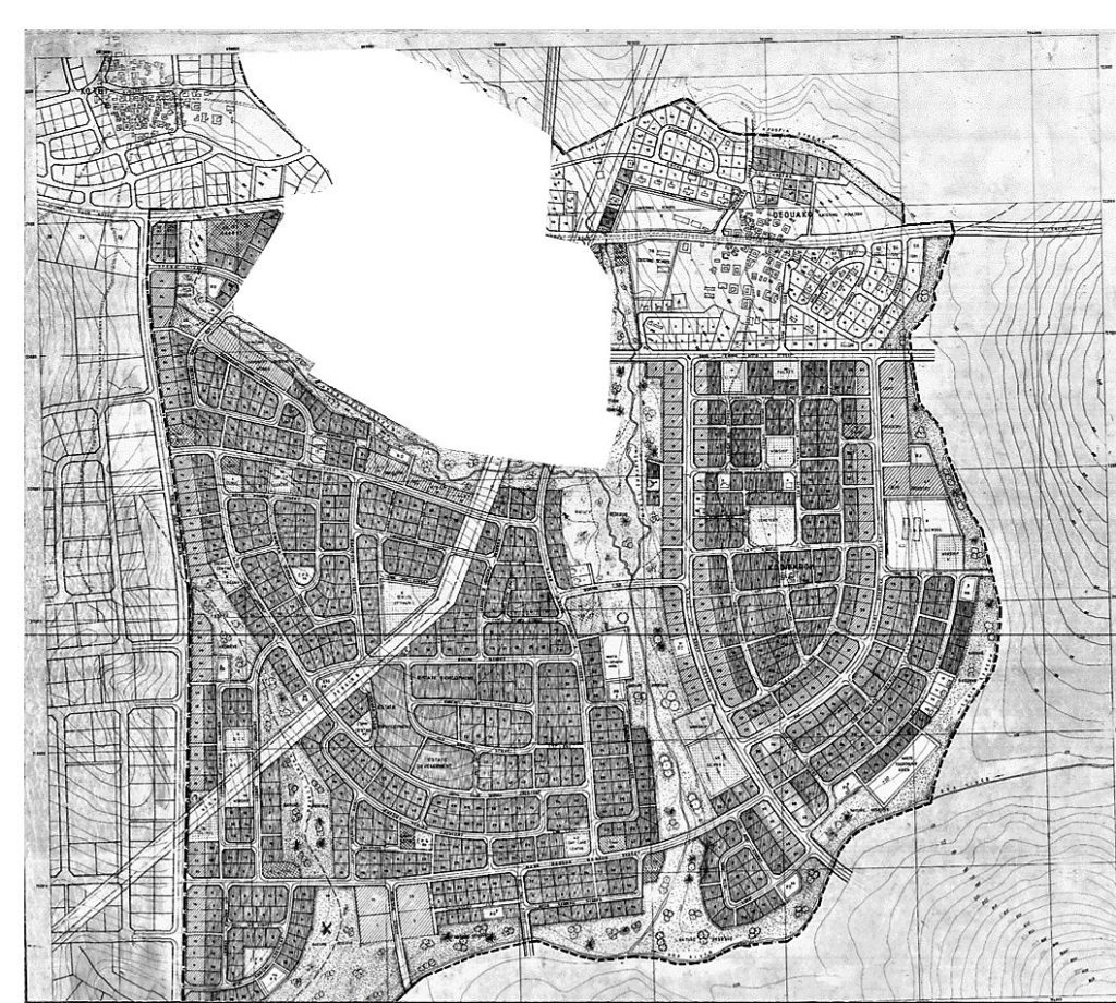
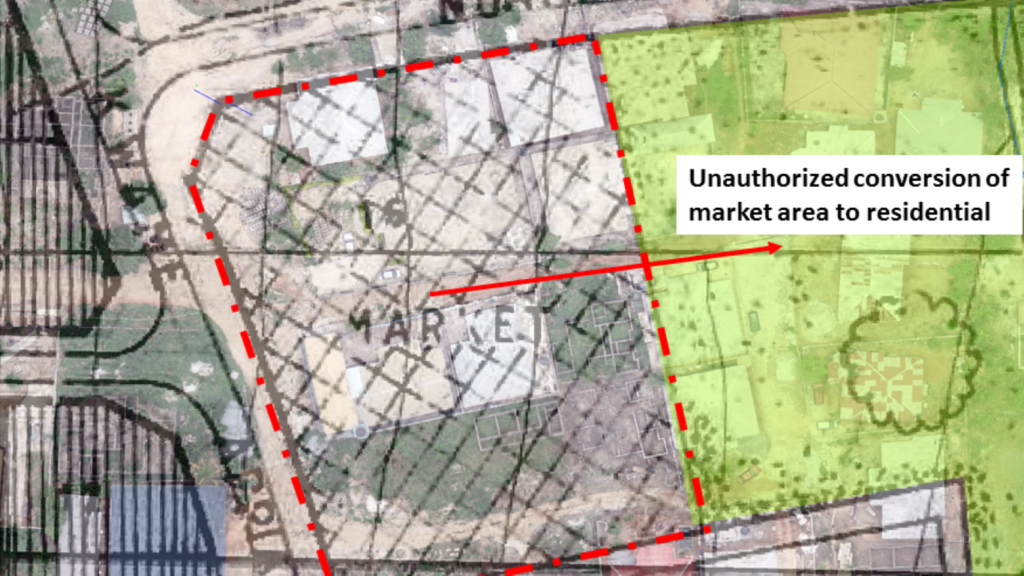
In order to identify cases of encroachment and buildings in unauthorised locations, both the land use plan and the orthophoto were geo-referenced to a common coordinate system (Accra Ghana Grid) so that they could both be referenced in the same location. The image below shows the result of the overlay method after projecting the land use scheme and the orthophoto to the same coordinate system.
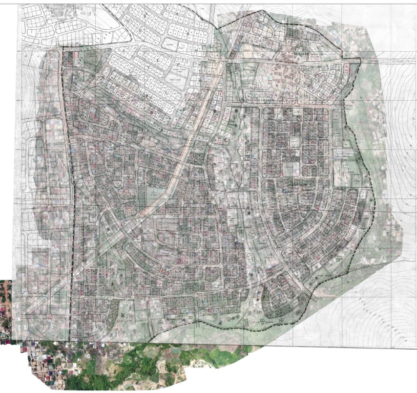
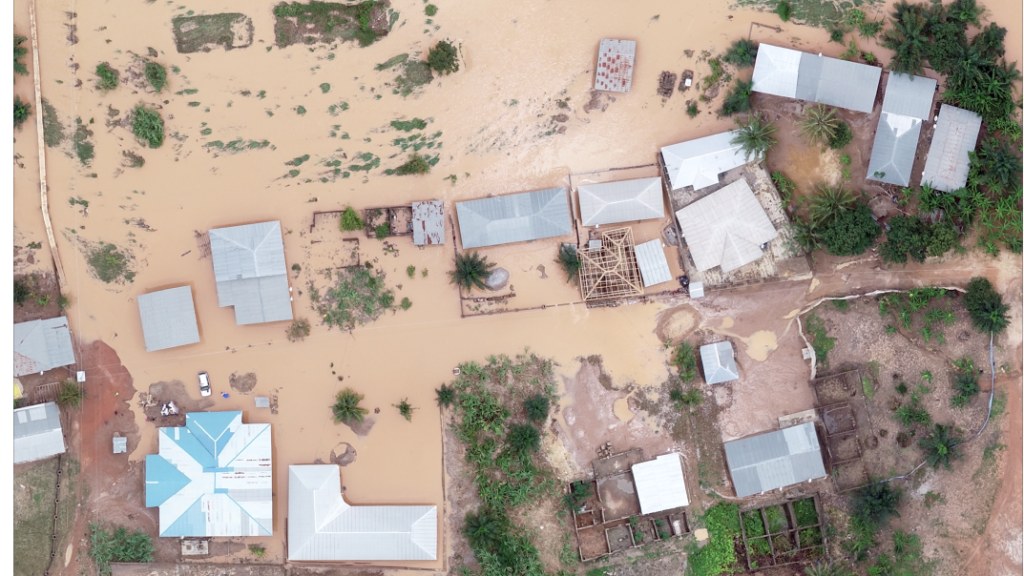
It was identified form the spatial analysis made it possible to see that most developers, especially those working in residential areas, have encroached open spaces or nature reserves – hardly adhering to the layout approved in Kodiekrom. This is a burgeoning problem in most urban areas in Ghana. Research carried out throughout the country, focusing on urban green spaces, shows that these are reducing at an alarming rate. Even if it is not immediately visible, this is having a strong impact in the air quality in all urban areas and in the general well-being of all citizens. The structures found not complying with the development plans in Kodiekrom were thus earmarked, with the authorities arguing for their demolition.
Key characteristics of an UAV-model
- Fast: The first metric to understand the impact of this approach is that it is quick and efficient – especially when compared to the traditional or conventional methods for monitoring development in a particular jurisdiction. Instead of taking several months, only two days were needed to produce all the deliverables, all of which showed higher accuracy levels;
- Accurate and exhaustive data: Traditional approaches used to monitor urban produce a limited amount of data. A single flight of a drone can generate data which can be used to produce orthophotos, digital terrain models, digital surface models and point clouds. These data sets and digital products can have multiple uses;
- A broader reach: An aerial mapping drone can take off and fly almost anywhere. The process is not limited by unreachable areas, unsafe steep slopes or harsh terrains. It is also not necessary to close down highways or train tracks. In fact, it is possible to capture data during operations without an organisational overhead;
- Future possibilities: Having digitalised data also means that it can be easily archived or stored, and then used again in the future, with new tools and for new applications. The data resulting from the project described here is all in digital format and can be used again for a range or purposes.
Ensuring that plans are followed
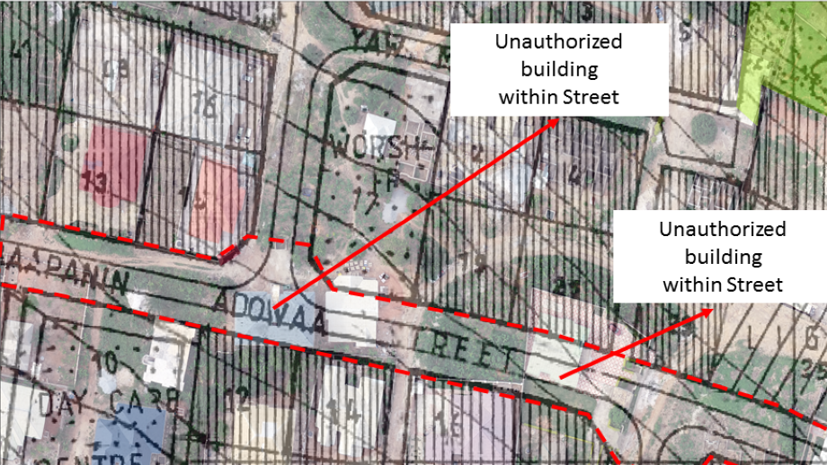
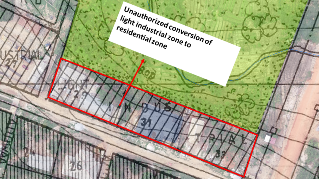
Land use plans are mostly prepared on the basis of a needs’ assessment process carried out by the PPD for a specific location. The results of such assessments determine the possible locations for green spaces, health infrastructures, libraries, schools, markets or government buildings. At the same time, physical accessibility is one of the key elements of land use planning. Hence, land use plans often propose streets and lanes to allow vehicles’ and / or pedestrians’ access to and from a location. Unfortunately, in many urban areas where there is a high demand for land, accessibility is highly compromised, and the intended uses are hardly adhered to. Developers often disregard the importance of streets and lanes during construction, and rarely inquire about the type of use zone their unit of land falls within. As a result, land space allocated for clinics or markets often turns into residential areas, responding to the demand and the high process that many people are willing to pay. And the same areas see severe congestion problems or become inaccessible, a problem which is especially serious in emergency situations (fire outbreaks or floods).
The spatial analysis conducted helped identify such issues. Superimposing the approved land use plan on the UAV orthophoto made it easier to see the encroachment of private buildings on the public spaces, and the drastic changes made to the original plans as shown in the images below. Local authorities have now the tools to prevent these serious problems in the future.
About the author
Justice Kwame Gyesi
Director
Ziongate Geospatial and Research Services Ltd.
c/o Department of Planning
Kwame Nkrumah University of Science and Technology (KNUST)
PMB University Post office|
Kumasi, Ghana
Email: info@ziongategeospatial.com
Phone: +233 540298632
www.ziongategeospatial.com
Acknowledgments
We acknowledge the Physical Planning Departments of Oforikrom Municipal Assembly and the Kodiekrom Traditional Council for their support