Spatial information is an essential component for the planning of informal settlements. An accurate base map is required to provide a model of the current situation to aid in designing proposed improvement plans for the settlements.
There are various sources of spatial information that can be used to generate base maps for the planning of informal settlements. The most available source is satellite imagery. However, the spatial resolution of satellite imagery is not sufficient to extract features like narrow paths and drains within the congested setup of informal settlement. This drawback can be mitigated by using aerial imagery from Unmanned Aerial Systems (UAVs) which fly low thus being able to capture data a high resolution.
During the month of April 2019, Maptech Consultants Limited was involved in the acquisition of UAV aerial imagery of three informal settlements within Kenya. The imagery was used to generate orthomosaics with a spatial resolution of approximately 3 cm. This data was used by urban planners to implement the objectives of the Kenya Informal Settlement Improvement Project (KISIP). This project was initiated by the Government of Kenya supported by the World Bank, the Swedish International Development Cooperation Agency (Sida) and the Agence Française de Development (AFD).
Data acquisition was accomplished using a DJI Phantom 3 Professional that has a 12MP RGB camera. Flight planning was done using Pix4D Capture which enabled us to pre-define flight paths that were fed into the drone to enable it to automatically capture images at regular intervals with a forward overlap of 80% and side lap of 70%. The images were post-processed using Agisoft Metashape Professional procured in partnership with CTA under the “Eyes in the Sky, smart Techs on the Ground” project.
The sites were relatively small (ranging from 1 ha – 16 ha) making the drone a perfect solution for data acquisition. Auxiliary data i.e. GNSS (Global Navigation Satellite System) positions of ground control points were collected using a geodetic GNSS equipment. These points were well distributed within the study areas and used to accurately georeference the generated orthomosaics.
The planners used this data for the following purposes:
- The orthomosaics were used as base maps to digitise features on the ground hence generating digital maps which were used for the purpose of socio-economic survey.
- Cadastral surveys were done to determine the plot boundaries within the settlements. These boundaries were overlaid onto the orthomosaics and subsequently used to improve security of tenure.
- The digital maps produced were also used as a basis to develop an improvement plan of the settlements in consultations with the community.

- Cadastral surveys were done to determine the plot boundaries within the settlements. These boundaries were overlaid onto the orthomosaics and subsequently used to improve security of tenure.
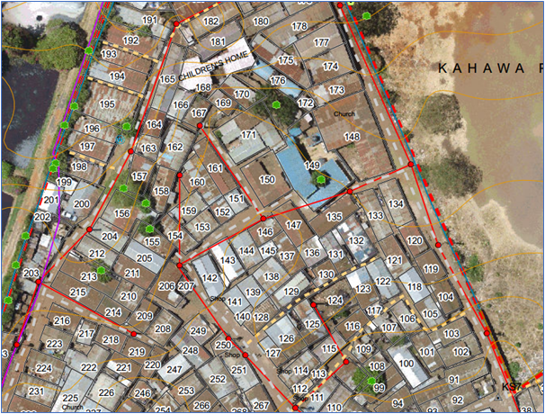
with spatial resolution of 3cm
- The digital maps produced were also used as a basis to develop an improvement plan of the settlements in consultations with the community.
Author: Frederick Arthur Onyango