In West Africa, a project has tested the use of unmanned aerial vehicles in producing accurate maps and providing ecological monitoring data of protected sites and habitats in wetlands. The drone-based technology was found to be more cost-effective and user friendly than more traditional satellite-based remote sensing and was able to provide desired outputs.
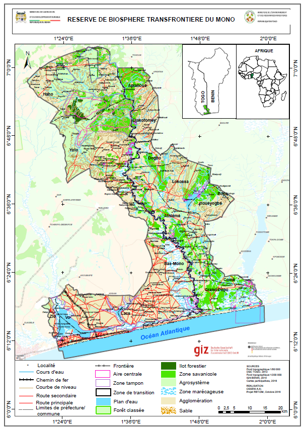
The Mono Delta Transboundary Biosphere Reserve (RBT) project supports the management and sustainable use of natural resources in the Mono river delta and its adjacent wetlands. As its name indicates, the reserve is located on the Mono Delta between two West African countries, Benin and Togo, and serves as a natural southern border.
The RBT contains natural habitats that are the refuge of many animal species, including the endangered red belly monkey (Cercopithecus erythrogaster). Some of the RBT’s numerous sites are protected by official status, whilst others benefit from the conservation efforts of non-governmental organisations and local populations. Among the RBT sites are the Togodo-South and the Togodo-North adjacent parks in Togo, the protected site of Adjamey in Benin, as well as three sites recognised as protected wetlands under the RAMSAR Convention.
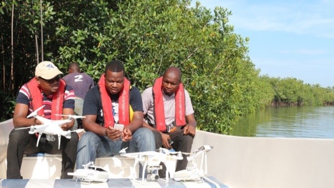
Although some are protected, RBT sites are still subject to illegal practices, such as poaching and illegal logging that affect the biodiversity in the areas under conservation. To help address this problem, following the creation of the reserve, the RBT project identified a set of management tools necessary for ensuring the ecological sustainability of the sites. Such tools include the development of environmental monitoring systems that take advantage of modern technologies, such as unmanned aerial vehicles (UAVs) – also known as drones – for remote sensing. Remote sensing usually relies on satellites or aircraft to collect data on the physical characteristics of land areas. During the last few years, UAVs have proven an effective technology for this task, providing real-time and detailed information for the management of relatively small sites that are difficult to access, such as the RBT. As such, the administration in charge of RBT project management tested the ability of UAVs to contribute to ecological monitoring of the areas under conservation. More specifically, in May 2017, the project contracted the services of Global Partners to test how drones can be used for mapping, ecological monitoring, and surveillance purposes.
The methodology of the tests can be divided into two essential steps: acquisition of RBT map imagery using UAVs, and orthorectification of the images to generate 2D and 3D maps. UAVs used in data collection of this kind can broadly be categorised as either rotary-winged or fixed-winged drones. Fixed-wing drones operate like airplanes and use the wings to provide the lift necessary to take off, fly and land, and need an open field for landing. In contrast, rotary wings function like helicopters and use the rotors for a vertical lift.
The location of the RBT in humid areas prohibited the use of fixed-wing drones and thus, two rotary drones (the DJI phantom professional 4 and 3) were used. The images collected by the drones were stitched together and then orthorectified, which is a process that consists of geometric correction of the images such that distortions of topographic relief are adjusted. The 2D maps obtained from this process, which are referred to as orthomosaics, accurately represent the earth’s surface. They are high-resolution maps with each pixel of the original images projected correctly onto the model of the digital surface, without distortions of perspective. The geographical coordinates (longitude, latitude, altitude) of each image, and the external orientation of the camera at the time the image was taken, were used to obtain a more precise geographical calibration. 3D maps were also created to calculate density measurements, such as the volume of woods.
Results
Comparison of the orthomosaic maps with those previously generated by the RBT project using traditional mapping tools corroborated one of the assumptions of this test – that data collected by UAVs can be used for creating accurate and reliable RBT site maps. The orthomosaics had the same geographic localisation as the maps created previously via ground-truthing.
The orthomosaics also showed a degree of detail unavailable on Google Earth images at certain resolutions. With a resolution of 300 m, the orthomosaics generated using the UAV images were similar to those obtained from Google Earth satellite data. At 100 m, some differences in the detail can be observed between the two maps, although the differences are not pronounced. At 60 and 30 m, however, there are distinguishing details on the maps obtained by the UAVs. Small objects on farm fields, for instance, are easily identifiable, such as tree branches of about 2 m in length and even maize plants separated by about 50 cm. This result shows that for monitoring activities that require a highly detailed view of the land, UAVs are more appropriate than free satellite data. Drones are also cheaper, fast, and can be used at will, which is not the case with satellites.
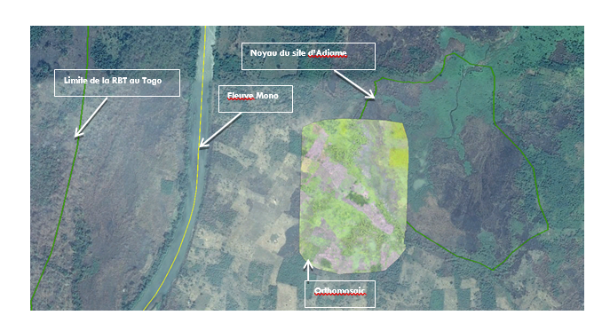
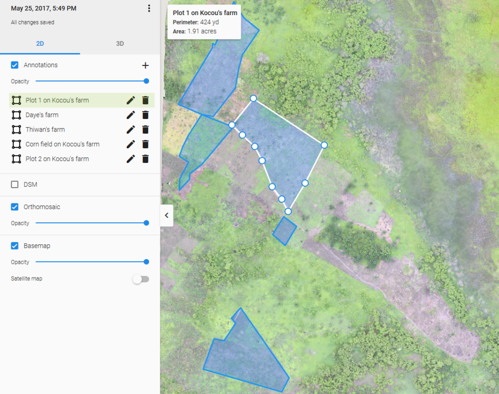
Another objective of the tests was to evaluate the usefulness of UAVs in detecting agricultural footprint and poaching indices, as well as the geographical location of sites under these pressures. As shown in the image of the Adjamey site below, on the orthomosaic maps, the presence of agricultural fields near the ‘buffer zone’ can be located. Buffer zones are areas peripheral to the area under protection where limited use of resources helps maintain the integrity of the protected area. Identifying agricultural encroachments around the protected area helps the project to target the relevant landowners and inform them of the conservation methods. UAVs can then also help monitor those agricultural fields and evaluate the impacts of the project’s sensitising campaigns.
Calculation of indices, such as volume and surface area, can help indicate a change in the size of areas under conservation due to illegal activities, such as the encroachment of farmers’ fields on protected land. For this test, the project looked at the site of the King Mouth in Azinko, one of the sites of the RBT, as a case study. Following the analysis of data collected by the UAVs, it appeared that this site has a perimeter of 170 m and covers an area of 0.19 ha, which corresponds to ground-truthing measurements of the area provided by the RBT Mono technical advisers. A comparison of UAVs data at different dates will help monitor the evolution of the areas under conservation.
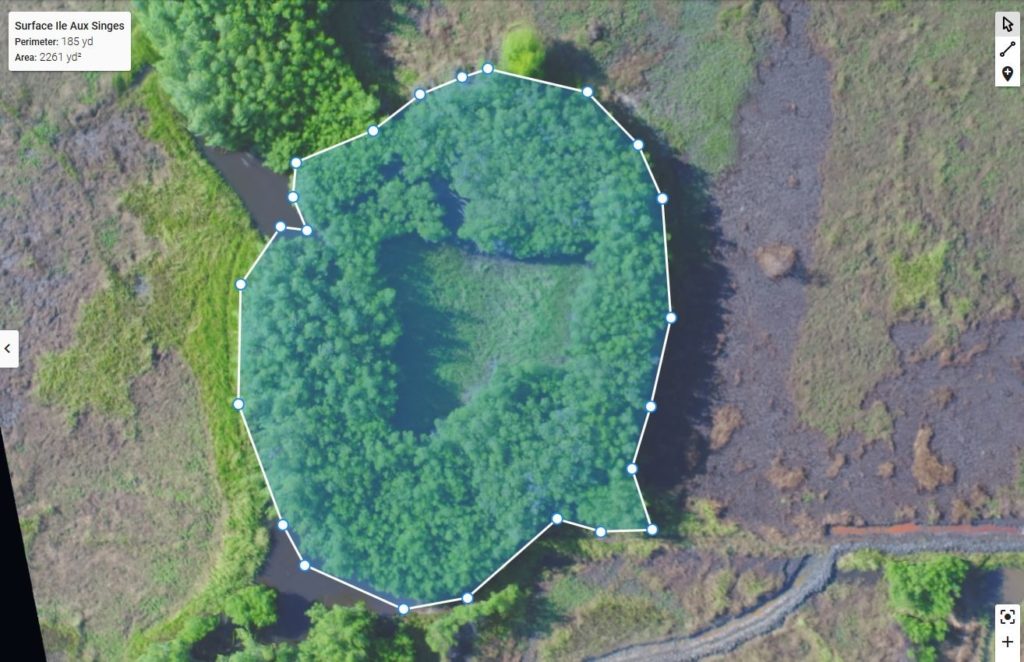
Calculation of indices, such as volume and surface area, can help indicate a change in the size of areas under conservation due to illegal activities, such as the encroachment of farmers’ fields on protected land. For this test, the project looked at the site of the King Mouth in Azinko, one of the sites of the RBT, as a case study. Following the analysis of data collected by the UAVs, it appeared that this site has a perimeter of 170 m and covers an area of 0.19 ha, which corresponds to ground-truthing measurements of the area provided by the RBT Mono technical advisers. A comparison of UAVs data at different dates will help monitor the evolution of the areas under conservation.
Conclusions
Although drones cannot yet completely replace existing observation tools and systems, such as aircraft or satellites, they have several advantages over these more traditional remote sensing devices. For instance, in the case of small protected areas, the use of aircraft or satellites is prohibitively expensive and requires qualified human resources for deployment, whilst drones are more affordable and easier to operate. Drones can also collect high-resolution images (up to a few square centimeters per pixel) below the cloud level, providing much more detail than freely available satellite imagery.
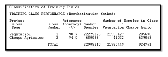
The details of data collection missions can easily be programmed within UAVs so that they are used following a preprogrammed mission. UAVs can also be deployed at will, provided weather conditions are favourable (no rain or strong wind), and national regulations are followed. The results of this project show that drones can be used for mapping and monitoring of conservation sites as the data they collect can be used for calculating indices, such as site perimeters, areas, and volumes useful for monitoring a change in areas under conservation. UAVs can also identify and locate the agricultural footprint on conservation areas. Finally, the different types of habitat on each site can be monitored by using methods such as classification of the orthomosaics.
About the authors:
Dr. Ouidoh Fructueuse
Managing Director at Global Partners
Email : frudenou@yahoo.fr
Dr. Abdelaziz Lawani
Founder of Global Partners
Assistant professor at Eastern Kentucky University
Email : abdelawani@gmail.com

This work is licensed under a Creative Commons Attribution-NonCommercial-NoDerivatives 4.0 International License.